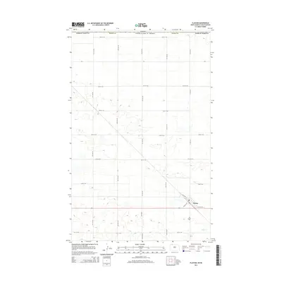
2014 Map of Flaxton
USGS Topo · Published 2014About this map
The international border between United States of America and Canada defines the northern edge of this North Dakota landscape, where the town of Flaxton serves as the primary hub of activity in Burke County. Located at the intersection of several local routes and named streets like NW Railway St and SW Davis Ave, the town's layout reflects a classic prairie rail-oriented design. To the southeast of the main settlement lies the Flaxton Cem, a key landmark for genealogical research in this rural region.
Find a feature on this map
24 named features on this map. Tap any name to fly to it.
Don’t see what you’re looking for? This feature index may not catch every label — zoom into the map to look around manually.
Map Details
Editions of this 2014 Flaxton Map
This is the sole edition of this map. No revisions or reprints were ever made.
Other maps of this area

1947 · Flaxton
USGS Topo · 1:24,000

1948 · Flaxton
USGS Topo · 1:24,000

1948 · Coteau
USGS Topo · 1:24,000

1948 · Woburn
USGS Topo · 1:24,000

1949 · Rennie Lake
USGS Topo · 1:24,000

1949 · Portal
USGS Topo · 1:24,000
1949 · Northgate
USGS Topo · 1:24,000

1950 · Flaxton
USGS Topo · 1:62,500

1950 · Portal
USGS Topo · 1:62,500

1953 · Williston
USGS Topo · 1:250,000