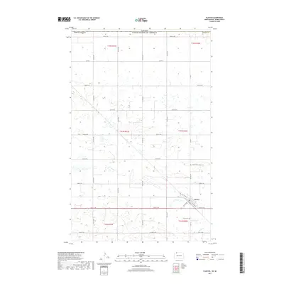
2017 Map of Flaxton
USGS Topo · Published 2017About this map
The town of Flaxton serves as the focal point of this northern plains landscape, situated just south of the Canada-United States border in Burke County. The settlement is organized around a traditional grid with street names like NW Railway St and SW Davis Ave reflecting its historical orientation toward regional transportation. The surrounding township is defined by the Public Land Survey System, with the terrain marked by numerous small depressions and wetlands characteristic of the glaciated plains. Genealogists and local historians can locate the Flaxton Cem south of the town site and the Flaxton Rural Lutheran Cem to the northwest. Beyond the immediate town limits, the landscape is primarily agricultural, bisected by Co Hwy 2 and drained by the subtle path of Stony Cr in the southeast corner.
Find a feature on this map
31 named features on this map. Tap any name to fly to it.
Don’t see what you’re looking for? This feature index may not catch every label — zoom into the map to look around manually.
Map Details
Editions of this 2017 Flaxton Map
This is the sole edition of this map. No revisions or reprints were ever made.
Other maps of this area

1947 · Flaxton
USGS Topo · 1:24,000

1948 · Flaxton
USGS Topo · 1:24,000

1948 · Coteau
USGS Topo · 1:24,000

1948 · Woburn
USGS Topo · 1:24,000

1949 · Rennie Lake
USGS Topo · 1:24,000

1949 · Portal
USGS Topo · 1:24,000
1949 · Northgate
USGS Topo · 1:24,000

1950 · Flaxton
USGS Topo · 1:62,500

1950 · Portal
USGS Topo · 1:62,500

1953 · Williston
USGS Topo · 1:250,000