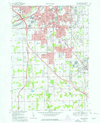
1969 Map of Flint South
USGS Topo · Published 1976About this map
The growing urban footprint of Flint and Burton expands southward toward Grand Blanc in the late 1960s, a period marked by the arrival of regional commercial hubs and infrastructure. Notable developments like the Bishop Airport and the Dort Mall Shopping Center indicate a shift toward automobile-centric commerce, while the Grand Trunk Western and Chesapeake and Ohio railroads continue to define the industrial corridors.
Find a feature on this map
84 named features on this map. Tap any name to fly to it.
Don’t see what you’re looking for? This feature index may not catch every label — zoom into the map to look around manually.
Map Details
Editions of this 1969 Flint South Map
3 editions found
Other maps of this area

1919 · Burt
USGS Topo · 1:62,500

1920 · Flint
USGS Topo · 1:62,500

1920 · Holly
USGS Topo · 1:62,500

1921 · Burt
USGS Topo · 1:62,500

1922 · Holly
USGS Topo · 1:62,500

1922 · Durand
USGS Topo · 1:62,500

1922 · Flint
USGS Topo · 1:62,500

1943 · Holly
USGS Topo · 1:62,500

1943 · Burt
USGS Topo · 1:62,500

1943 · Durand
USGS Topo · 1:62,500