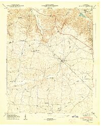
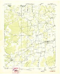
1947 Map of Flintville
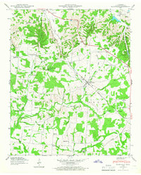
USGS Topo · Published 1967About this map
The Flint River winds through the heart of this post-war Tennessee landscape, flanked by the prominent heights of Pea Ridge. The area is characterized by a dense network of rural infrastructure, including several small educational centers like Benson Sch and Vann Sch. The industrial and utility footprint of the region is evident in the Fayetteville Pumping Station near Kelso and the State Fish Hatchery located in the eastern portion of the quadrangle. Transportation is anchored by the Nashville Chattanooga and St Louis railroad, which services the community at Flintville and passing through Milners Switch. This 1940s survey reveals a landscape of family-named landmarks and local heritage sites, from Sycamore Swamp to several small community churches like Gum Springs Ch and Lucy Memorial Ch. Genealogy researchers will find significant value in the numerous family burial grounds documented, including Bostick Cem and Warren Cem.
Find a feature on this map
66 named features on this map. Tap any name to fly to it.
Don’t see what you’re looking for? This feature index may not catch every label — zoom into the map to look around manually.
Map Details
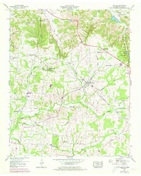
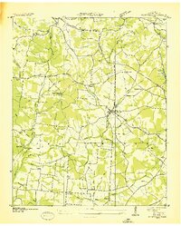
Editions of this 1947 Flintville Map
3 editions found
Other maps of this area

1888 · Scottsboro
USGS Topo · 1:125,000

1888 · Huntsville
USGS Topo · 1:125,000

1892 · Huntsville
USGS Topo · 1:125,000

1892 · Scottsboro
USGS Topo · 1:125,000

1936 · King Cove
USGS Topo · 1:24,000
1936 · Flintville
USGS Topo · 1:24,000

1936 · Fisk
USGS Topo · 1:24,000

1936 · Lincoln
USGS Topo · 1:24,000
1936 · Huntland
USGS Topo · 1:24,000
1936 · New Market
USGS Topo · 1:24,000