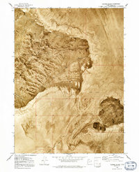
1973 Map of Floating Island
USGS Topo · Published 1991About this map
Silver Island Mountains dominate this orthophotomap, showing the stark contrast between the elevated ridges and the vast, surrounding Mud Flat. At the peak of this range, Cobb Peak stands as a prominent landmark overlooking the salt flats of western Utah. This 1970s record captures the unique intersection of topography and high-speed motorsport history, as seen in the southern portion of the sheet where the International Racetrack Overrun extends onto the flats. Small-scale mining activity is evidenced by scattered prospects along the western slopes, while the isolated landform of Floating Island rises out of the basin to the east. The map provides a detailed view of the natural drainage and erosion patterns through Silver Island Canyon, illustrating the geomorphology of the Great Salt Lake Desert during this era.
Find a feature on this map
8 named features on this map. Tap any name to fly to it.
Don’t see what you’re looking for? This feature index may not catch every label — zoom into the map to look around manually.
Map Details
Editions of this 1973 Floating Island Map
2 editions found
Other maps of this area

1953 · Tooele
USGS Topo · 1:250,000

1954 · Brigham City
USGS Topo · 1:250,000

1955 · Tooele
USGS Topo · 1:250,000

1958 · Brigham City
USGS Topo · 1:250,000

1962 · Brigham City
USGS Topo · 1:250,000

1970 · Crater Island
USGS Topo · 1:24,000

1971 · Graham Peak
USGS Topo · 1:24,000

1971 · Bonneville Racetrack
USGS Topo · 1:24,000

1973 · Floating Island SW
USGS Topo · 1:24,000

1973 · Floating Island SE
USGS Topo · 1:24,000