
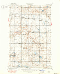
1932 Map of Flora
USGS Topo · Published 1932About this map
The Sheyenne River cuts a deep, winding valley across this central North Dakota landscape, separating the townships of South Viking and West Antelope. Surveyed at the end of the 1920s, the map reveals a rural economy structured by the Northern Pacific and Great Northern railroads. Small rail-side settlements like Flora and Josephine serve as anchor points for the surrounding agricultural tracts.
Find a feature on this map
31 named features on this map. Tap any name to fly to it.
Don’t see what you’re looking for? This feature index may not catch every label — zoom into the map to look around manually.
Map Details
Editions of this 1932 Flora Map
2 editions found
Other maps of this area

1931 · Oberon
USGS Topo · 1:62,500

1932 · Grahams Island
USGS Topo · 1:62,500

1943 · Maddock
USGS Topo · 1:62,500

1945 · Maddock
USGS Topo · 1:62,500

1948 · New Rockford
USGS Topo · 1:62,500

1948 · Cathay
USGS Topo · 1:62,500

1948 · Fessenden
USGS Topo · 1:62,500

1948 · Bremen
USGS Topo · 1:24,000

1949 · Bremen
USGS Topo · 1:24,000

1949 · Fessenden East
USGS Topo · 1:24,000