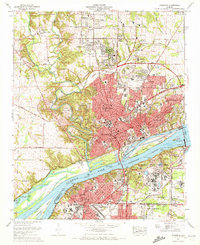
1971 Map of Florence
USGS Topo · Published 1972About this map
Florence and its industrial neighbor Sheffield dominate this river-bound landscape in the early 1970s. The map illustrates a city in transition, where established institutions like Florence State College and the Court House are surrounded by expanding residential districts such as Sherwood Forest and Weeden Heights. The Tennessee River serves as the central artery, controlled by the massive Wilson Dam and feeding into Pickwick Lake. South of the river, the Muscle Shoals Reservation and the National Fertilizer Development Center highlight the area's role as a center for federal utility and research.
Find a feature on this map
82 named features on this map. Tap any name to fly to it.
Don’t see what you’re looking for? This feature index may not catch every label — zoom into the map to look around manually.
Map Details
Editions of this 1971 Florence Map
3 editions found
Other maps of this area

1914 · Muscle Shoals
USGS Topo · 1:48,000

1916 · Muscle Shoals
USGS Topo · 1:62,500

1924 · Tuscumbia
USGS Topo · 1:48,000

1924 · Gravelly Springs
USGS Topo · 1:48,000

1925 · Barton
USGS Topo · 1:62,500

1926 · Tuscumbia
USGS Topo · 1:62,500

1926 · Barton
USGS Topo · 1:48,000

1926 · Gravelly Springs
USGS Topo · 1:62,500

1929 · Barton
USGS Topo · 1:62,500

1936 · Pride
USGS Topo · 1:24,000