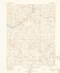
1959 Map of Florissant
USGS Topo · Published 1961About this map
Florissant and its surroundings reflect a mid-century Colorado landscape defined by high-altitude ranching and nascent water management. The South Platte River and Lake George serve as central hydrologic features, with the Elevenmile Canyon Reservoir appearing behind its dam and spillway to the west. This period shows a robust network of family-held lands across the Pike National Forest, including the Abell Ranch, Witcher Ranch, and the Hartsel Ranch (Witcher Unit). These named properties, alongside features like the Petrified Forest Area and Balanced Rock, suggest a region where cattle grazing, geological interest, and the early stages of tourism were well-established.
Find a feature on this map
70 named features on this map. Tap any name to fly to it.
Don’t see what you’re looking for? This feature index may not catch every label — zoom into the map to look around manually.
Map Details
Editions of this 1959 Florissant Map
4 editions found
Other maps of this area

1893 · Platte Canyon
USGS Topo · 1:125,000

1894 · Pikes Peak
USGS Topo · 1:125,000

1901 · Pikes Peak
USGS Topo · 1:125,000

1901 · Pikes Peak
USGS Topo · 1:62,500

1942 · Cover Mtn.
USGS Topo · 1:62,500

1948 · Cover Mtn.
USGS Topo · 1:62,500

1951 · Cripple Creek South
USGS Topo · 1:24,000

1951 · Cripple Creek North
USGS Topo · 1:24,000

1953 · Denver
USGS Topo · 1:250,000

1954 · Signal Butte
USGS Topo · 1:24,000