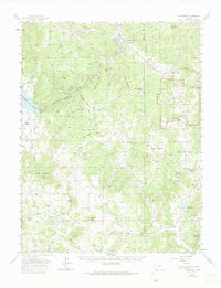
1959 Map of Florissant
USGS Topo · Published 1975About this map
The South Platte River and its numerous mountain tributaries carve through this high-altitude landscape, defining the character of the region during the mid-20th century. The settlement of Florissant sits at the eastern edge, just north of the Florissant Fossil Beds National Monument, while Lake George serves as a hub near the Elevenmile Canyon Reservoir. The map reveals a robust ranching culture with family-named operations like Abell Ranch, Lewis Ranch, and Witcher Ranch scattered across the Pike National Forest.
Find a feature on this map
74 named features on this map. Tap any name to fly to it.
Don’t see what you’re looking for? This feature index may not catch every label — zoom into the map to look around manually.
Map Details
Editions of this 1959 Florissant Map
4 editions found
Other maps of this area

1893 · Platte Canyon
USGS Topo · 1:125,000

1894 · Pikes Peak
USGS Topo · 1:125,000

1901 · Pikes Peak
USGS Topo · 1:125,000

1901 · Pikes Peak
USGS Topo · 1:62,500

1942 · Cover Mtn.
USGS Topo · 1:62,500

1948 · Cover Mtn.
USGS Topo · 1:62,500

1951 · Cripple Creek South
USGS Topo · 1:24,000

1951 · Cripple Creek North
USGS Topo · 1:24,000

1953 · Denver
USGS Topo · 1:250,000

1954 · Signal Butte
USGS Topo · 1:24,000