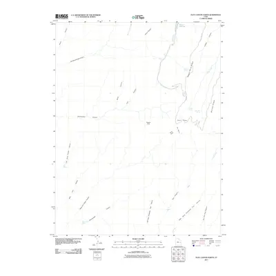
2011 Map of Floy Canyon North
USGS Topo · Published 2011About this map
Wagon Road Ridge and Morman Ridge dominate this portion of the East Tavaputs Plateau, defining a landscape carved by deep drainages like Floy Canyon and Rattlesnake Canyon. This 2011 survey by the U.S. Geological Survey documents the complex topography of Grand County, where high-elevation landmarks such as Roan Peaks overlook the deep basins below. Water sources are critical identifiers in this arid environment, with several named features like Showerbath Spring, Wilcox Spring, and Table Rock Spring serving as vital points of reference for those navigating the backcountry. Sego Canyon Rd provides the primary access route through the eastern sector, winding near Hill Creek and the Weaver Reservoir. The map illustrates a network of traditional trails and canyons, including Trail Canyon and Flat Nose George Canyon, reflecting the area's history of ranching and exploration.
Find a feature on this map
34 named features on this map. Tap any name to fly to it.
Don’t see what you’re looking for? This feature index may not catch every label — zoom into the map to look around manually.
Map Details
Editions of this 2011 Floy Canyon North Map
This is the sole edition of this map. No revisions or reprints were ever made.
Other maps of this area

1885 · East Tavaputs
USGS Topo · 1:250,000

1956 · Grand Junction
USGS Topo · 1:250,000

1959 · Grand Junction
USGS Topo · 1:250,000

1960 · Grand Junction
USGS Topo · 1:250,000

1962 · Grand Junction
USGS Topo · 1:250,000

1963 · Tenmile Canyon
USGS Topo · 1:62,500

1963 · Moonwater Point
USGS Topo · 1:62,500
1963 · Floy Canyon
USGS Topo · 1:62,500

1963 · Sego Canyon
USGS Topo · 1:62,500

1964 · Grand Junction
USGS Topo · 1:250,000