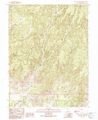
1991 Map of Floy Canyon South
USGS Topo · Published 1991About this map
Floy Wash acts as the central drainage for this high-desert landscape in Grand County, Utah, where deep canyons and high points define the terrain. This 1991 provisional map captures the region's ranching and prospecting history, marked by the presence of the Crescent Mine near the base of Crescent Butte. The drainage system is complex, fed by the Left Hand Threeforks and Right Hand Threeforks in the north, while several named springs like Tom Spring, Cub Spring, and Trough Spring provide vital water points in an otherwise arid environment. The map details a network of canyons including Ute Canyon, Horse Canyon, and the sprawling Crescent Canyon system, illustrating how topography dictated movement and resource extraction in this remote part of the Colorado Plateau.
Find a feature on this map
20 named features on this map. Tap any name to fly to it.
Don’t see what you’re looking for? This feature index may not catch every label — zoom into the map to look around manually.
Map Details
Editions of this 1991 Floy Canyon South Map
This is the sole edition of this map. No revisions or reprints were ever made.
Other maps of this area

1885 · East Tavaputs
USGS Topo · 1:250,000

1885 · La Sal
USGS Topo · 1:250,000

1956 · Moab
USGS Topo · 1:250,000

1956 · Grand Junction
USGS Topo · 1:250,000

1958 · Crescent Junction
USGS Topo · 1:62,500

1958 · Thompson
USGS Topo · 1:62,500

1959 · Grand Junction
USGS Topo · 1:250,000

1959 · Moab
USGS Topo · 1:250,000

1960 · Moab
USGS Topo · 1:250,000

1960 · Grand Junction
USGS Topo · 1:250,000