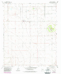
1973 Map of Floyd
USGS Topo · Published 1987About this map
The settlement of Floyd anchors this High Plains landscape, depicted here during the mid-1970s with updates from the early 1980s. The town's grid is clearly defined, showing the Cem on its western edge and a series of Water Tanks near the central Floyd well. The surrounding Roosevelt County terrain is characterized by ephemeral basins and depression lakes, including Tierra Blanca Lake, Gregory Lake, and Smith Lake, which serve as vital catchments in this arid environment. Evidence of local industry and infrastructure is visible through the presence of several Gravel Pits, a Substa, and a prominent Radio Tower. To the south, the natural drainage of Boone Draw cuts across the plains, while a long-distance Pipeline segment traverses the southern sections, illustrating the region's role in resource transportation and agricultural support.
Find a feature on this map
13 named features on this map. Tap any name to fly to it.
Don’t see what you’re looking for? This feature index may not catch every label — zoom into the map to look around manually.
Map Details
Editions of this 1973 Floyd Map
2 editions found
Other maps of this area

1954 · Clovis
USGS Topo · 1:250,000

1957 · Portair
USGS Topo · 1:62,500

1957 · Melrose
USGS Topo · 1:62,500

1957 · Portales
USGS Topo · 1:62,500

1958 · Clovis
USGS Topo · 1:250,000

1973 · Floyd
USGS Topo · 1:24,000

1973 · Lewiston Lake
USGS Topo · 1:24,000

1973 · Tule Lake
USGS Topo · 1:24,000

1973 · Upton
USGS Topo · 1:24,000

1973 · Floyd SE
USGS Topo · 1:24,000