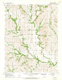
1964 Map of Flush
USGS Topo · Published 1965About this map
Flush serves as the central settlement in this mid-1960s depiction of eastern Pottawatomie County, where agricultural life is defined by a dense network of drainages. The landscape is deeply carved by watercourses including Rock Creek, Pleasant Run, and Slough Creek, creating a highly dissected topography that dictates the placement of rural landmarks. Genealogy and local history researchers will find the Admatha Cem and the Sales Community Hall positioned among the upland ridges. Evidence of local industry and infrastructure is visible at the Quarry near the eastern boundary and a Gaging Station on Elm Creek. The map documents the rural character of the region just before significant modern developments, capturing the intricate section-line road network and the way townships like Louisville, St George, and Blue converge in this corner of the Kansas prairie.
Find a feature on this map
18 named features on this map. Tap any name to fly to it.
Don’t see what you’re looking for? This feature index may not catch every label — zoom into the map to look around manually.
Map Details
Editions of this 1964 Flush Map
2 editions found
Other maps of this area

1886 · Junction City
USGS Topo · 1:125,000

1889 · Wamego
USGS Topo · 1:125,000

1889 · Junction City
USGS Topo · 1:125,000

1894 · Junction City
USGS Topo · 1:125,000

1894 · Wamego
USGS Topo · 1:125,000

1947 · Manhattan
USGS Topo · 1:62,500

1950 · Manhattan
USGS Topo · 1:24,000

1953 · Wamego
USGS Topo · 1:24,000

1953 · St George
USGS Topo · 1:24,000
1955 · Manhattan
USGS Topo · 1:24,000