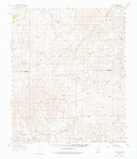
1961 Map of Flying H
USGS Topo · Published 1975About this map
Flying H stands at the southern end of a vast ranching landscape straddling the line between Lincoln and Chaves counties. Surveyed in the early 1960s, this area is defined by a complex network of canyons and drainage systems, most notably the Rio Felix and Crooked Creek. The map documents numerous family-named landmarks that speak to the region's agricultural heritage, including the Slaughter Ranch, Mc Knight Ranch, and Watson Ranch.
Find a feature on this map
39 named features on this map. Tap any name to fly to it.
Don’t see what you’re looking for? This feature index may not catch every label — zoom into the map to look around manually.
Map Details
Editions of this 1961 Flying H Map
2 editions found
Other maps of this area

1954 · Carlsbad
USGS Topo · 1:250,000

1955 · Roswell
USGS Topo · 1:250,000

1958 · Carlsbad
USGS Topo · 1:250,000

1958 · Roswell
USGS Topo · 1:250,000

1960 · Teel Ranch
USGS Topo · 1:62,500

1961 · Flying H
USGS Topo · 1:62,500

1961 · Lincoln
USGS Topo · 1:62,500

1961 · Indian Bluff
USGS Topo · 1:62,500

1961 · Tinnie
USGS Topo · 1:62,500

1962 · Roswell
USGS Topo · 1:250,000