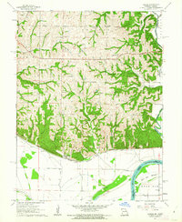
1961 Map of Forbes
USGS Topo · Published 1962About this map
The Nodaway River and Missouri River converge at the foot of the bluffs in this 1961 survey of the Missouri-Kansas borderlands. The landscape transitions sharply from the rugged, wooded drainages of Barrett Hollow and Whales Hollow to the broad, fertile expanse of Burr Oak Bottom. This floodplain, protected by a series of Floodgate installations, reflects the agricultural importance of the Missouri River valley before major modern alterations.
Find a feature on this map
38 named features on this map. Tap any name to fly to it.
Don’t see what you’re looking for? This feature index may not catch every label — zoom into the map to look around manually.
Map Details
Editions of this 1961 Forbes Map
3 editions found
Other maps of this area

1885 · Atchison
USGS Topo · 1:125,000

1888 · Atchison
USGS Topo · 1:125,000

1893 · Atchison
USGS Topo · 1:125,000

1924 · St. Joseph
USGS Topo · 1:62,500

1926 · Saint Joseph
USGS Topo · 1:62,500

1926 · Oregon
USGS Topo · 1:62,500

1926 · Maitland
USGS Topo · 1:62,500

1927 · Bolckow
USGS Topo · 1:62,500

1945 · Bolckow
USGS Topo · 1:62,500

1950 · Kansas City
USGS Topo · 1:250,000