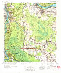
1970 Map of Fordoche
USGS Topo · Published 1972About this map
Stonewall Plantation and the surrounding riverfront communities along the Mississippi River anchor this 1970 landscape, where the interplay of hydraulic engineering and the petrochemical industry is clearly visible. The region is dominated by the Morganza Floodway and the Atchafalaya Basin Floodway, massive drainage corridors designed to manage the river's flow. Between these managed spillways, the land is etched with a network of bayous including Bayou Fordoche and Bayou Latenache, alongside extensive petroleum developments such as the Fordoche Oil and Gas Field and Ravenswood Oil Field.
Find a feature on this map
83 named features on this map. Tap any name to fly to it.
Don’t see what you’re looking for? This feature index may not catch every label — zoom into the map to look around manually.
Map Details
Editions of this 1970 Fordoche Map
This is the sole edition of this map. No revisions or reprints were ever made.
Other maps of this area

1906 · Bayou Sara
USGS Topo · 1:125,000

1935 · Osca Bayou
USGS Topo · 1:62,500

1939 · St. Francisville
USGS Topo · 1:62,500

1939 · Fordoche
USGS Topo · 1:62,500

1940 · Grosse Tete
USGS Topo · 1:62,500

1940 · Arnaudville
USGS Topo · 1:62,500

1941 · Batchelor
USGS Topo · 1:62,500

1953 · Maringouin
USGS Topo · 1:24,000

1953 · New Roads
USGS Topo · 1:24,000

1954 · Fordoche
USGS Topo · 1:24,000