
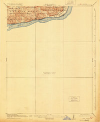
1916 Map of Fords Ferry
USGS Topo · Published 1916About this map
Ohio River shoreline developments and the complex borderlands between Illinois and Kentucky define this 1914 survey. The topography is dominated by the prominent bluffs of Battery Rock and the riverfront settlement of Cave in Rock, a site deeply tied to early river navigation and frontier history. This preliminary edition highlights a landscape dotted with localized commerce and education, featuring rural landmarks like Fraileys Store and Peters Cr Store.
Find a feature on this map
19 named features on this map. Tap any name to fly to it.
Don’t see what you’re looking for? This feature index may not catch every label — zoom into the map to look around manually.
Map Details
Editions of this 1916 Fords Ferry Map
2 editions found
Other maps of this area

1907 · Morganfield
USGS Topo · 1:62,500

1908 · Princeton
USGS Topo · 1:62,500

1909 · Providence
USGS Topo · 1:62,500

1910 · Princeton
USGS Topo · 1:62,500

1916 · Shawneetown
USGS Topo · 1:62,500

1916 · Golconda
USGS Topo · 1:62,500

1916 · Equality
USGS Topo · 1:62,500

1920 · Goloonda
USGS Topo · 1:48,000

1921 · Fords Ferry
USGS Topo · 1:48,000

1921 · Golconda
USGS Topo · 1:62,500