
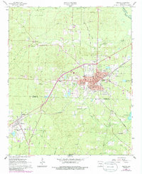
1966 Map of Fordyce
USGS Topo · Published 1967About this map
Fordyce serves as the focal point of this mid-1960s survey, situated at the junction of the Chicago Rock Island and Pacific Railroad and the St Louis Southwestern Railway. The town's grid is well-defined, featuring landmarks such as the Courthouse, Po, and the Radio Tower (KBJT). To the west, the smaller community of Thornton lies along the rail line near the Mt Zion Cem, while the rural surroundings are dotted with family-named burial grounds like Barnes Cem and Stroud Cem.
Find a feature on this map
58 named features on this map. Tap any name to fly to it.
Don’t see what you’re looking for? This feature index may not catch every label — zoom into the map to look around manually.
Map Details
Editions of this 1966 Fordyce Map
2 editions found
Other maps of this area

1903 · Camden
USGS Topo · 1:125,000

1953 · El Dorado
USGS Topo · 1:250,000

1957 · El Dorado
USGS Topo · 1:250,000

1958 · El Dorado
USGS Topo · 1:250,000

1960 · El Dorado
USGS Topo · 1:250,000

1966 · Kingsland
USGS Topo · 1:24,000
1969 · Ivan
USGS Topo · 1:24,000
1970 · Fordyce NE
USGS Topo · 1:24,000

1973 · Bearden
USGS Topo · 1:24,000
1973 · Hopeville
USGS Topo · 1:24,000