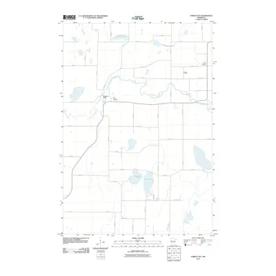
2010 Map of Forest City
USGS Topo · Published 2010About this map
Forest City serves as the focal point of this Meeker County survey, situated where Csah 2 meets the winding path of the North Fork Crow River. The landscape is a classic example of Minnesota's glaciated terrain, defined by a network of drainage systems like County Ditch Number Forty-two and several large water bodies including Richardson Lake and Dunns Lake. For those researching local families, the map identifies several burial grounds scattered across the rural township, such as Saint Gertrude Cemetery near the river bend and Ostmark Cemetery further east. The layout of the road network, including Csah 11 and Csah 14, reflects the persistent grid of agricultural property lines that have shaped this region for over a century. This 2010 edition from the U.S. Geological Survey provides a clear view of the hydrological and transportation infrastructure of the time.
Find a feature on this map
38 named features on this map. Tap any name to fly to it.
Don’t see what you’re looking for? This feature index may not catch every label — zoom into the map to look around manually.
Map Details
Editions of this 2010 Forest City Map
This is the sole edition of this map. No revisions or reprints were ever made.
Other maps of this area

1953 · Saint Cloud
USGS Topo · 1:250,000

1957 · Saint Cloud
USGS Topo · 1:250,000

1958 · Saint Cloud
USGS Topo · 1:250,000

1958 · Dassel
USGS Topo · 1:62,500

1967 · Litchfield South
USGS Topo · 1:24,000

1967 · Litchfield North
USGS Topo · 1:24,000

1967 · Watkins
USGS Topo · 1:24,000

1967 · Kimball
USGS Topo · 1:24,000
1967 · Eden Valley
USGS Topo · 1:24,000
1982 · Dassel
USGS Topo · 1:24,000