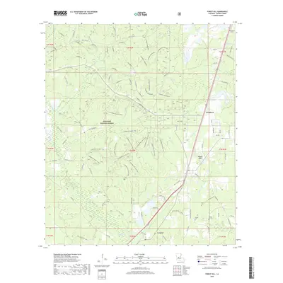
2018 Map of Forest Hill
USGS Topo · Published 2018About this map
Kisatchie National Forest dominates this portion of Rapides Parish, characterized by a complex network of forestry roads and recreational paths. The Claiborne Boy Scout Trail winds extensively through the piney woods, crossing numerous drainages such as Bayou Hospital and Hurricane Creek. The settlement of Forest Hill serves as a local hub near the eastern edge, supported by the presence of the Forest Hill Speedway and several small communities like Bringhurst and Longleaf. Local family history is preserved in small burial grounds including Moore Cem, Butters Cem, and Liberty Hill Cemetery. The landscape is defined by its water system, where Spring Creek and Barber Creek converge, illustrating the transition between upland timber tracts and the fertile creek bottoms of central Louisiana.
Find a feature on this map
72 named features on this map. Tap any name to fly to it.
Don’t see what you’re looking for? This feature index may not catch every label — zoom into the map to look around manually.
Map Details
Editions of this 2018 Forest Hill Map
This is the sole edition of this map. No revisions or reprints were ever made.
Other maps of this area

1935 · Pawnee
USGS Topo · 1:31,680

1935 · Turkey Creek
USGS Topo · 1:62,500

1935 · Lecompte
USGS Topo · 1:62,500

1942 · Oakdale
USGS Topo · 1:62,500

1949 · Glenmora
USGS Topo · 1:31,680

1949 · Turkey Creek
USGS Topo · 1:62,500

1952 · Lake Charles
USGS Topo · 1:250,000

1953 · Alexandria
USGS Topo · 1:250,000
1954 · Pawnee
USGS Topo · 1:31,680

1954 · Lake Charles
USGS Topo · 1:250,000