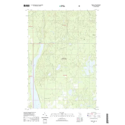
2019 Map of Forest Lake
USGS Topo · Published 2019About this map
The Au Train River and its accompanying Au Train Falls define the northern hydrology of this Alger County landscape, which remains largely within the Hiawatha National Forest. Small settlements such as Dixon, Stillman, and Vail sit along the east-west corridor of M-94, serving as points of reference within the timbered interior. The map illustrates a complex network of multi-use trails that trace the region's logging and transit history, including the N Country National Scenic Trail and the Bay De Noc - Grand Island trail. In the south, the terrain is dotted with numerous glacial lakes and ponds, from the large Sixteenmile Lake to the secluded Little Round Lake. The presence of the Cleveland Cliffs Basin and the Coalwood Grade ATV trail highlights the transition from industrial resource management to modern recreational use in Michigan's Upper Peninsula.
Find a feature on this map
36 named features on this map. Tap any name to fly to it.
Don’t see what you’re looking for? This feature index may not catch every label — zoom into the map to look around manually.
Map Details
Editions of this 2019 Forest Lake Map
This is the sole edition of this map. No revisions or reprints were ever made.
Other maps of this area

1958 · Corner Lake
USGS Topo · 1:62,500

1958 · Trenary
USGS Topo · 1:62,500

1958 · Munising
USGS Topo · 1:62,500

1958 · Au Train
USGS Topo · 1:62,500

1958 · Marquette
USGS Topo · 1:250,000

1960 · Marquette
USGS Topo · 1:250,000

1961 · Marquette
USGS Topo · 1:250,000

1968 · Marquette
USGS Topo · 1:250,000

1983 · Munising
USGS Topo · 1:100,000
1985 · Munising
USGS Topo · 1:24,000