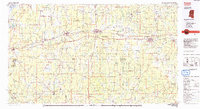
1984 Map of Forest
USGS Topo · Published 1984About this map
The Bienville National Forest dominates the central landscape of this 1984 study, framing the corridor of the Illinois Central Gulf railroad. This industrial and ecological spine connects several established Mississippi towns, including Brandon, Morton, and Forest. To the northwest, the map captures the expansive Ross R Barnett Reservoir on the Pearl River, a feature that redefined the regional topography and recreation, alongside Roosevelt State Park.
Find a feature on this map
128 named features on this map. Tap any name to fly to it.
Don’t see what you’re looking for? This feature index may not catch every label — zoom into the map to look around manually.
Map Details
Editions of this 1984 Forest Map
2 editions found
Other maps of this area

1903 · Jackson
USGS Topo · 1:125,000

1905 · Jackson
USGS Topo · 1:48,000

1906 · Florence
USGS Topo · 1:62,500

1908 · Jackson
USGS Topo · 1:62,500

1908 · Florence
USGS Topo · 1:62,500

1921 · Forest
USGS Topo · 1:48,000

1922 · Forest
USGS Topo · 1:62,500

1922 · Morton
USGS Topo · 1:48,000

1922 · Pelahatchee
USGS Topo · 1:48,000

1924 · Pelahatchee
USGS Topo · 1:62,500