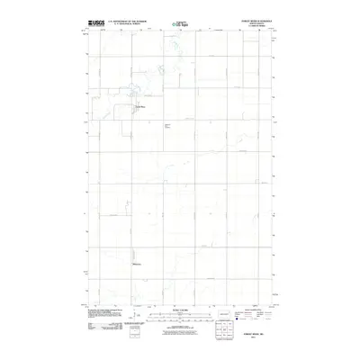
2011 Map of Forest River
USGS Topo · Published 2011About this map
The Forest River winds through the northern plains of Walsh County, defining the agricultural landscape of this region during the early 21st century. The settlement of Forest River sits along the river's path, organized around a grid that includes Front St and Carpenter Ave W. This area is characterized by a precise network of section-line roads, such as 147th Ave NE and 56th St NE, which facilitate the local farming economy. Further south, the community of Johnstown marks another small population center at the intersection of Johnstown St and 34th Ave NE. Notable local landmarks include the Memorial Park Cemetery, situated along County Hwy-2. The map illustrates the transition from traditional county roads like County Rd-19 to the modern rural numbering system.
Find a feature on this map
28 named features on this map. Tap any name to fly to it.
Don’t see what you’re looking for? This feature index may not catch every label — zoom into the map to look around manually.
Map Details
Editions of this 2011 Forest River Map
This is the sole edition of this map. No revisions or reprints were ever made.
Other maps of this area

1926 · Ardoch
USGS Topo · 1:62,500

1943 · Grafton
USGS Topo · 1:62,500

1952 · Thief River Falls
USGS Topo · 1:250,000

1956 · Thief River Falls
USGS Topo · 1:250,000

1957 · Thief River Falls
USGS Topo · 1:250,000

1963 · Inkster NE
USGS Topo · 1:24,000

1963 · Veseleyville
USGS Topo · 1:24,000
1963 · Forest River
USGS Topo · 1:24,000
1963 · Inkster SE
USGS Topo · 1:24,000
1963 · Gilby
USGS Topo · 1:24,000