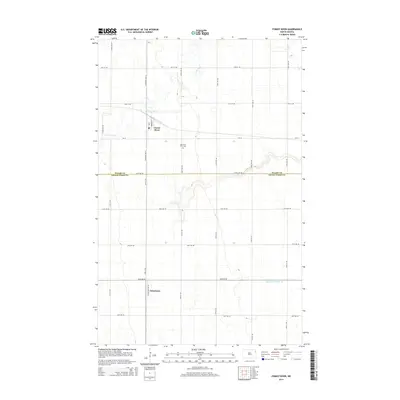
2014 Map of Forest River
USGS Topo · Published 2014About this map
The Forest River winds through the Red River Valley, carving a narrow riparian corridor across the flat agricultural landscape of North Dakota. In the early 21st century, this area remains defined by a precise section-line road grid and small prairie settlements. The town of Forest River sits at the junction of Carpenter Ave W and CR-19, served by a local Po that has long anchored the community. To the south, the village of Johnstown marks another key point of local gathering along Johnstown Ave NE. The landscape is largely dedicated to large-scale farming, evidenced by the extensive drainage network including County Ditch Number 19. Local history and family ties are preserved at the Memorial Park Cem, situated centrally between the two primary settlements.
Find a feature on this map
29 named features on this map. Tap any name to fly to it.
Don’t see what you’re looking for? This feature index may not catch every label — zoom into the map to look around manually.
Map Details
Editions of this 2014 Forest River Map
This is the sole edition of this map. No revisions or reprints were ever made.
Other maps of this area

1926 · Ardoch
USGS Topo · 1:62,500

1943 · Grafton
USGS Topo · 1:62,500

1952 · Thief River Falls
USGS Topo · 1:250,000

1956 · Thief River Falls
USGS Topo · 1:250,000

1957 · Thief River Falls
USGS Topo · 1:250,000

1963 · Inkster NE
USGS Topo · 1:24,000

1963 · Veseleyville
USGS Topo · 1:24,000
1963 · Forest River
USGS Topo · 1:24,000
1963 · Inkster SE
USGS Topo · 1:24,000
1963 · Gilby
USGS Topo · 1:24,000