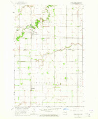
1963 Map of Forest River
USGS Topo · Published 1964About this map
The Forest River winds through the heart of the Red River Valley in the early 1960s, anchoring the small agricultural hub of Forest River. This landscape is defined by the rigid section lines of the Northern Plains, intersected by the diagonal paths of the Northern Pacific and Soo Line railroads. These rail corridors were vital to the grain-based economy of Walsh County, connecting the town of Forest River and the nearby settlement of Johnstown.
Find a feature on this map
11 named features on this map. Tap any name to fly to it.
Don’t see what you’re looking for? This feature index may not catch every label — zoom into the map to look around manually.
Map Details
Editions of this 1963 Forest River Map
This is the sole edition of this map. No revisions or reprints were ever made.
Other maps of this area

1926 · Ardoch
USGS Topo · 1:62,500

1943 · Grafton
USGS Topo · 1:62,500

1952 · Thief River Falls
USGS Topo · 1:250,000

1956 · Thief River Falls
USGS Topo · 1:250,000

1957 · Thief River Falls
USGS Topo · 1:250,000

1963 · Inkster NE
USGS Topo · 1:24,000

1963 · Veseleyville
USGS Topo · 1:24,000
1963 · Inkster SE
USGS Topo · 1:24,000
1963 · Gilby
USGS Topo · 1:24,000

1967 · Thief River Falls
USGS Topo · 1:250,000