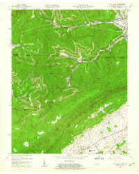
1959 Map of Fork Ridge
USGS Topo · Published 1960About this map
Coal-country commerce and rugged terrain define this borderland at the close of the 1950s, where the L & N RR and Southern railroads snake through deep valleys to service the mining operations of the Log Mountains. The settlement at Fork Ridge serves as a central hub for the local labor force, supported by the Fork Ridge Sch and nearby religious centers like Richardson Chapel. The map reveals a landscape heavily shaped by industry, with numerous tipple sites and strip mines dotting the spurs of the Mingo Mountains. Further south, the terrain transitions into the agricultural clearings of Poor Valley, where family names are preserved at the Yoakum Cem and Sharp Cem. This survey documents a critical moment in the Appalachian economy, balancing intensive resource extraction around Bryson with the established rural life along Tackett Creek.
Find a feature on this map
69 named features on this map. Tap any name to fly to it.
Don’t see what you’re looking for? This feature index may not catch every label — zoom into the map to look around manually.
Map Details
Editions of this 1959 Fork Ridge Map
2 editions found
Other maps of this area

1886 · Cumberland Gap
USGS Topo · 1:125,000

1888 · Cumberland Gap
USGS Topo · 1:125,000

1891 · Cumberland Gap
USGS Topo · 1:125,000

1897 · Maynardville
USGS Topo · 1:125,000

1900 · Maynardville
USGS Topo · 1:125,000

1903 · Middlesboro
USGS Topo · 1:48,000

1927 · Middlesboro
USGS Topo · 1:62,500

1930 · Middlesboro
USGS Topo · 1:62,500

1935 · Mingo Mountains
USGS Topo · 1:24,000

1935 · Cumberland Gap
USGS Topo · 1:24,000