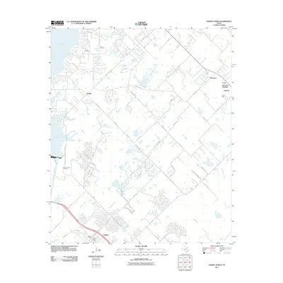
2011 Map of Forney North
USGS Topo · Published 2011About this map
Lake Ray Hubbard dominates the western edge of this landscape, its waters reaching into the mouth of the East Fork Trinity River. The eastern shores show the expanding footprint of Heath, while further inland, the settlements of McLendon-Chisholm and Forney anchor the local road network. Numerous small water bodies and creeks, including Buffalo Creek and Mustang Creek, weave through the terrain, suggesting a complex local drainage system that has influenced the placement of early homesteads and cemeteries.
Find a feature on this map
67 named features on this map. Tap any name to fly to it.
Don’t see what you’re looking for? This feature index may not catch every label — zoom into the map to look around manually.
Map Details
Editions of this 2011 Forney North Map
This is the sole edition of this map. No revisions or reprints were ever made.
Other maps of this area

1891 · Dallas
USGS Topo · 1:125,000

1893 · Dallas
USGS Topo · 1:125,000

1912 · Rockwall
USGS Topo · 1:31,680

1919 · Royse City
USGS Topo · 1:62,500

1954 · Dallas
USGS Topo · 1:250,000

1956 · Kaufman
USGS Topo · 1:62,500

1958 · Dallas
USGS Topo · 1:250,000

1959 · Mesquite
USGS Topo · 1:24,000

1959 · Seagoville
USGS Topo · 1:24,000
1959 · Rowlett
USGS Topo · 1:24,000