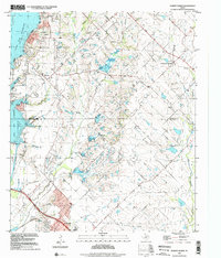
1995 Map of Forney North
USGS Topo · Published 2002About this map
Forney anchors the southern edge of this landscape, where the prairie of north-central Texas transitions toward the waters of Lake Ray Hubbard. Compiled from 1995 imagery, the map documents a period of significant growth at the edge of the Dallas-Fort Worth metroplex, capturing the suburban development surrounding Heath and Mc Lendon-Chisholm. Despite the expanding residential footprint, the land remains etched with its rural history, preserved in a network of family and community burial grounds such as Kaiser Cem, Peek Cem, and Chisholm Cem. Drainage patterns are defined by the convergence of several waterways including Buffalo Creek, Mustang Creek, and Brushy Creek, which carve through the terrain toward the reservoir. The presence of the Mt Rose Ch and small cemeteries like Valley View Cem suggests the persistent social geography of the earlier agricultural communities that preceded the modern sprawl.
Find a feature on this map
26 named features on this map. Tap any name to fly to it.
Don’t see what you’re looking for? This feature index may not catch every label — zoom into the map to look around manually.
Map Details
Editions of this 1995 Forney North Map
This is the sole edition of this map. No revisions or reprints were ever made.
Other maps of this area

1891 · Dallas
USGS Topo · 1:125,000

1893 · Dallas
USGS Topo · 1:125,000

1912 · Rockwall
USGS Topo · 1:31,680

1919 · Royse City
USGS Topo · 1:62,500

1954 · Dallas
USGS Topo · 1:250,000

1956 · Kaufman
USGS Topo · 1:62,500

1958 · Dallas
USGS Topo · 1:250,000

1959 · Mesquite
USGS Topo · 1:24,000

1959 · Seagoville
USGS Topo · 1:24,000
1959 · Rowlett
USGS Topo · 1:24,000