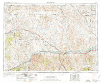
1954 Map of Forsyth
USGS Topo · Published 1974About this map
The Yellowstone River and Musselshell River valleys anchor this mid-century survey of eastern Montana, where the regional economy was defined by the intersection of rail transport and emerging energy production. The Northern Pacific and Chicago Milwaukee St Paul and Pacific railroads parallel these river systems, supporting ranching hubs and siding communities such as Forsyth, Ingomar, and Sumatra. The discovery of petroleum is evident in the western portion of the map, specifically within the North West Sumatra Oil Field and Ragged Point Oil Field, signaling a shift toward industrial extraction in an otherwise pastoral landscape.
Find a feature on this map
70 named features on this map. Tap any name to fly to it.
Don’t see what you’re looking for? This feature index may not catch every label — zoom into the map to look around manually.
Map Details
Editions of this 1954 Forsyth Map
3 editions found
Other maps of this area

1893 · Huntley
USGS Topo · 1:125,000

1894 · Fort Custer
USGS Topo · 1:125,000

1953 · Miles City
USGS Topo · 1:250,000

1954 · Billings
USGS Topo · 1:250,000

1954 · Hardin
USGS Topo · 1:250,000

1954 · Jordan
USGS Topo · 1:250,000

1954 · Ekalaka
USGS Topo · 1:250,000

1954 · Forsyth
USGS Topo · 1:250,000

1954 · Roundup
USGS Topo · 1:250,000

1954 · Glendive
USGS Topo · 1:250,000