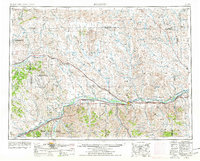
1954 Map of Forsyth
USGS Topo · Published 1977About this map
The Yellowstone River corridor serves as the primary artery for transport and settlement in this mid-century view of southeastern Montana. The town of Forsyth stands as a central hub, flanked by smaller communities like Rosebud and Hysham along the tracks of the Burlington Northern railroad. To the north, the landscape transitions into a network of drainage basins and reservoirs, including Black Sea Reservoir and Blacktail Reservoir, which supported the region's agricultural and ranching interests.
Find a feature on this map
60 named features on this map. Tap any name to fly to it.
Don’t see what you’re looking for? This feature index may not catch every label — zoom into the map to look around manually.
Map Details
Editions of this 1954 Forsyth Map
3 editions found
Other maps of this area

1893 · Huntley
USGS Topo · 1:125,000

1894 · Fort Custer
USGS Topo · 1:125,000

1953 · Miles City
USGS Topo · 1:250,000

1954 · Billings
USGS Topo · 1:250,000

1954 · Hardin
USGS Topo · 1:250,000

1954 · Jordan
USGS Topo · 1:250,000

1954 · Ekalaka
USGS Topo · 1:250,000

1954 · Forsyth
USGS Topo · 1:250,000

1954 · Roundup
USGS Topo · 1:250,000

1954 · Glendive
USGS Topo · 1:250,000