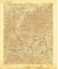
1907 Map of Forsyth
USGS Topo · Published 1921About this map
Forsyth and the winding course of the White River anchor this early twentieth-century survey of the Ozark highlands. The landscape is defined by its reliance on the river system before the era of modern bridges, evidenced by numerous river crossings including Mabry Ferry, Coombs Ferry, and Hensley Ferry. To the north, the St Louis & San Francisco RR connects timber and mining communities like Chadwick and Sparta. Geological features such as Marble Cave and Kathley Cave are clearly noted, alongside prominent heights like Dewey Bald and Whiterock Bluff. The map also documents a dense network of country schools, such as Bald Knob School and Leafers Glory School, which served the dispersed settlements of Taneyville, Galena, and Branson during a time when agriculture and local milling at Kissee Mills drove the regional economy.
Find a feature on this map
114 named features on this map. Tap any name to fly to it.
Don’t see what you’re looking for? This feature index may not catch every label — zoom into the map to look around manually.
Map Details
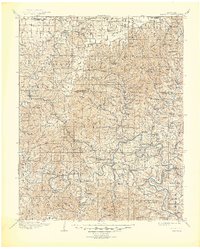
Editions of this 1907 Forsyth Map
3 editions found

Other maps of this area

1884 · Springfield
USGS Topo · 1:125,000

1886 · Greenfield
USGS Topo · 1:125,000

1886 · Springfield
USGS Topo · 1:125,000

1888 · Greenfield
USGS Topo · 1:125,000

1893 · Yellville
USGS Topo · 1:125,000

1900 · Eureka Springs
USGS Topo · 1:125,000

1901 · Eureka Springs
USGS Topo · 1:125,000

1903 · Yellville
USGS Topo · 1:125,000

1904 · Harrison
USGS Topo · 1:125,000

1905 · Harrison
USGS Topo · 1:125,000