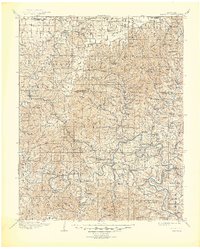
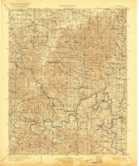
1907 Map of Forsyth
USGS Topo · Published 1945About this map
The James River and White River carve winding paths through this section of the Ozarks during the early twentieth century. This survey, conducted shortly after the turn of the century, depicts the region before modern hydroelectric dams transformed these river valleys into massive reservoirs. The landscape is dotted with small agricultural settlements like Forsyth, Galena, and the namesake mineral spring site of Ponce de Leon. River life is central to the era's economy, as evidenced by several vital crossings including Hensley Ferry, Mabry Ferry, and Coombs Ferry.
Find a feature on this map
145 named features on this map. Tap any name to fly to it.
Don’t see what you’re looking for? This feature index may not catch every label — zoom into the map to look around manually.
Map Details
Editions of this 1907 Forsyth Map
3 editions found

Other maps of this area

1884 · Springfield
USGS Topo · 1:125,000

1886 · Greenfield
USGS Topo · 1:125,000

1886 · Springfield
USGS Topo · 1:125,000

1888 · Greenfield
USGS Topo · 1:125,000

1893 · Yellville
USGS Topo · 1:125,000

1900 · Eureka Springs
USGS Topo · 1:125,000

1901 · Eureka Springs
USGS Topo · 1:125,000

1903 · Yellville
USGS Topo · 1:125,000

1904 · Harrison
USGS Topo · 1:125,000

1905 · Harrison
USGS Topo · 1:125,000