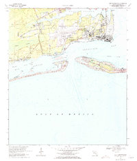
1970 Map of Fort Barrancas
USGS Topo · Published 1971About this map
Pensacola Naval Air Station dominates the northern shoreline in this 1970 survey, revealing the complex infrastructure of coastal defense and aviation. The landscape is a strategic blend of historic fortifications and active military installations, featuring the Forrest Sherman Field runways and the smaller Chevalier Field near Pensacola Bay. History is layered here, with the Fort Barrancas and Fort San Carlos structures standing near modern facilities like the Radio Facility and U.S. Coast Guard station.
Find a feature on this map
50 named features on this map. Tap any name to fly to it.
Don’t see what you’re looking for? This feature index may not catch every label — zoom into the map to look around manually.
Map Details
Editions of this 1970 Fort Barrancas Map
4 editions found
Other maps of this area

1921 · Pensacola
USGS Topo · 1:62,500

1921 · Fort Barrancas
USGS Topo · 1:62,500

1941 · Fort Barrancas
USGS Topo · 1:62,500

1941 · Pensacola
USGS Topo · 1:62,500

1942 · Pensacola
USGS Topo · 1:62,500

1943 · Fort Barrancas
USGS Topo · 1:62,500

1944 · Perdido Bay North
USGS Topo · 1:25,000

1944 · West Pensacola
USGS Topo · 1:25,000

1944 · Perdido Bay South
USGS Topo · 1:25,000

1944 · Gulf Breeze
USGS Topo · 1:25,000