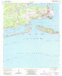
1970 Map of Fort Barrancas
USGS Topo · Published 1987About this map
Pensacola Naval Air Station dominates this coastal landscape, showing the military infrastructure of the mid-20th century alongside deep-rooted fortifications. The map details the operational layout of Forrest Sherman Field and Chevalier Field, while preserving the footprints of older defensive works like Fort Barrancas and the nearby Fort Redoubt Ruins. This intersection of modern naval aviation and 19th-century coastal defense is further anchored by the Barrancas National Cemetery and the U S Naval Rifle Range.
Find a feature on this map
46 named features on this map. Tap any name to fly to it.
Don’t see what you’re looking for? This feature index may not catch every label — zoom into the map to look around manually.
Map Details
Editions of this 1970 Fort Barrancas Map
4 editions found
Other maps of this area

1921 · Pensacola
USGS Topo · 1:62,500

1921 · Fort Barrancas
USGS Topo · 1:62,500

1941 · Fort Barrancas
USGS Topo · 1:62,500

1941 · Pensacola
USGS Topo · 1:62,500

1942 · Pensacola
USGS Topo · 1:62,500

1943 · Fort Barrancas
USGS Topo · 1:62,500

1944 · Perdido Bay North
USGS Topo · 1:25,000

1944 · West Pensacola
USGS Topo · 1:25,000

1944 · Perdido Bay South
USGS Topo · 1:25,000

1944 · Gulf Breeze
USGS Topo · 1:25,000