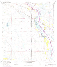
1953 Map of Fort Basinger
USGS Topo · Published 1973About this map
The Kissimmee River meanders across this landscape, defining the boundary between Okeechobee and Highlands Counties in the mid-20th century. The settlement of Fort Basinger serves as a primary local landmark, situated near a gaging station and the Seaboard Coast Line railroad. This 1953 survey, updated with 1972 photorevisions, captures the hydrological complexity of the region before significant modern alteration, featuring secondary water systems like Chandler Slough and the Doughty Cutoff.
Find a feature on this map
14 named features on this map. Tap any name to fly to it.
Don’t see what you’re looking for? This feature index may not catch every label — zoom into the map to look around manually.
Map Details
Editions of this 1953 Fort Basinger Map
2 editions found
Other maps of this area

1952 · Okeechobee NW
USGS Topo · 1:24,000

1953 · Taylor Creek NW
USGS Topo · 1:24,000

1953 · Basinger
USGS Topo · 1:24,000

1953 · Brighton NW
USGS Topo · 1:24,000

1953 · Fort Basinger
USGS Topo · 1:24,000

1953 · Brighton
USGS Topo · 1:24,000

1953 · Basinger SW
USGS Topo · 1:24,000

1953 · Basinger NW
USGS Topo · 1:24,000

1953 · Taylor Creek SW
USGS Topo · 1:24,000

1956 · Fort Pierce
USGS Topo · 1:250,000