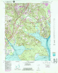
1965 Map of Fort Belvoir
USGS Topo · Published 1983About this map
Gunston Hall and the historic Gunston Plantation anchor the southern reaches of this landscape along the Potomac River, representing the deep colonial roots of Fairfax County. This mid-1960s survey, updated with 1980s bathymetry and photorevisions, illustrates the complex intersection of military, residential, and natural spaces. The expansive Fort Belvoir Military Reservation dominates the central terrain, containing Davison Airfield and DeWitt Hospital, while burgeoning residential settlements like Newington, Lorton, and Woodbridge surround the base. Critical transportation corridors, including the Richmond Fredericksburg and Potomac Railroad and Richmond Highway, facilitate movement through the area. To the south, the preservation of Mason Neck is evident through the Mason Neck State Park and Mason Neck National Wildlife Refuge, protecting the shoreline where Pohick Bay and Gunston Cove meet the main river channel.
Find a feature on this map
69 named features on this map. Tap any name to fly to it.
Don’t see what you’re looking for? This feature index may not catch every label — zoom into the map to look around manually.
Map Details
Editions of this 1965 Fort Belvoir Map
4 editions found
Other maps of this area

1890 · Mt. Vernon
USGS Topo · 1:125,000

1891 · Mt. Vernon
USGS Topo · 1:125,000

1894 · Mt. Vernon
USGS Topo · 1:125,000

1897 · Mt. Vernon
USGS Topo · 1:125,000

1900 · Washington
USGS Topo · 1:62,500

1913 · Indian Head
USGS Topo · 1:62,500

1915 · Fairfax
USGS Topo · 1:62,500

1923 · Indian Head
USGS Topo · 1:48,000

1925 · Indian Head
USGS Topo · 1:62,500

1927 · Quantico
USGS Topo · 1:62,500