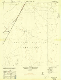
1948 Map of Fort Bliss NE
USGS Topo · Published 1948About this map
Fort Bliss Military Reservation dominates this 1948 military edition, showing the high-desert landscape north of El Paso just after World War II. The map reveals a transition from traditional ranching to modern industrial and military infrastructure. While McElroy Cow Camp Abandoned is marked as defunct, Shearman Ranch remains a functional outpost near the Southern Pacific railroad line. The presence of the El Paso Natural Gas Company Pipe Line Road and accompanying Water towers and a Reservoir highlights the postwar expansion of utilities across this arid region. Compiled from 1944 aerial photography, the sheet records the specific configuration of the Military Reservation boundaries and desert tracks at a time when the area's role in national defense was rapidly evolving.
Find a feature on this map
11 named features on this map. Tap any name to fly to it.
Don’t see what you’re looking for? This feature index may not catch every label — zoom into the map to look around manually.
Map Details
Editions of this 1948 Fort Bliss NE Map
This is the sole edition of this map. No revisions or reprints were ever made.
Other maps of this area

1896 · El Paso
USGS Topo · 1:125,000

1908 · El Paso
USGS Topo · 1:125,000

1939 · Heuco Tanks
USGS Topo · 1:62,500

1940 · Heuco Tanks
USGS Topo · 1:62,500

1940 · Newman
USGS Topo · 1:62,500

1941 · El Paso
USGS Topo · 1:31,680

1941 · Desert
USGS Topo · 1:62,500

1942 · Fort Bliss
USGS Topo · 1:62,500

1943 · Desert
USGS Topo · 1:62,500

1943 · Newman
USGS Topo · 1:62,500