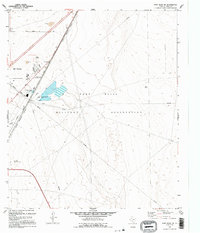
1995 Map of Fort Bliss NE
USGS Topo · Published 1995About this map
The Fort Bliss Military Reservation dominates this 1990s landscape on the northern edge of El Paso, where the urban corporate boundary meets expansive federal lands. The intersection of military utility and civic infrastructure is evident through the presence of the Sewage Treatment Plant and Industrial Waste Ponds protected by a network of levees. Transportation and communication arteries like Dyer Street and Ashley Road service the area, while the Plane Port and various Radio Towers highlight the region's mid-century aviation and signaling history. Local recreation is represented by the Fort Bliss Rod and Gun Club, situated along the western edge of the desert flats. This survey, revised from 1954 and 1991 photography, captures the transition of the West Texas desert into a managed industrial and military corridor.
Find a feature on this map
18 named features on this map. Tap any name to fly to it.
Don’t see what you’re looking for? This feature index may not catch every label — zoom into the map to look around manually.
Map Details
Editions of this 1995 Fort Bliss NE Map
This is the sole edition of this map. No revisions or reprints were ever made.
Other maps of this area

1896 · El Paso
USGS Topo · 1:125,000

1908 · El Paso
USGS Topo · 1:125,000

1939 · Heuco Tanks
USGS Topo · 1:62,500

1940 · Heuco Tanks
USGS Topo · 1:62,500

1940 · Newman
USGS Topo · 1:62,500

1941 · El Paso
USGS Topo · 1:31,680

1941 · Desert
USGS Topo · 1:62,500

1942 · Fort Bliss
USGS Topo · 1:62,500

1943 · Desert
USGS Topo · 1:62,500

1943 · Newman
USGS Topo · 1:62,500