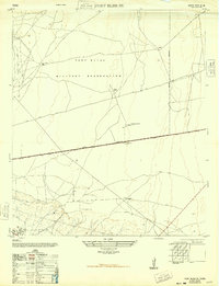
1948 Map of Fort Bliss SE
USGS Topo · Published 1948About this map
The Fort Bliss Military Reservation dominates this 1948 landscape, capturing a transitional period in El Paso County where military utility and agricultural outposts coexisted on the high desert. While the Military Highway and Carlsbad Highway provide the primary east-west corridors, the presence of localized operations like the Sherman Hog Ranch, Chicken Ranch, and Price Dairy points to a time when decentralized agricultural production supported the growing military and civilian population. Vital water infrastructure for this arid environment is documented through features such as the Bakers Well Windmill and various other windmills. The map also records essential infrastructure of the era, including several Radio Towers and the Hueco Road, providing a rare look at the footprint of El Paso’s northeastern periphery before later urban and base expansion.
Find a feature on this map
14 named features on this map. Tap any name to fly to it.
Don’t see what you’re looking for? This feature index may not catch every label — zoom into the map to look around manually.
Map Details
Editions of this 1948 Fort Bliss SE Map
This is the sole edition of this map. No revisions or reprints were ever made.
Other maps of this area

1896 · El Paso
USGS Topo · 1:125,000

1908 · El Paso
USGS Topo · 1:125,000

1939 · Ysleta
USGS Topo · 1:62,500

1939 · Heuco Tanks
USGS Topo · 1:62,500

1940 · Heuco Tanks
USGS Topo · 1:62,500

1941 · El Paso
USGS Topo · 1:31,680

1941 · Clint
USGS Topo · 1:62,500

1941 · Ysleta
USGS Topo · 1:62,500

1942 · Fort Bliss
USGS Topo · 1:62,500

1943 · El Paso
USGS Topo · 1:31,680
Featured Places
- El Paso, TX
- Turf Estates Number 1 Colonia, TX
- Las Palmas Number 2 Colonia, El Paso
- Las Palmas Colonia, El Paso
- Del Norte Heights, El Paso