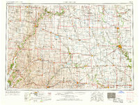
1954 Map of Fort Dodge
USGS Topo · Published 1968About this map
The Des Moines River and its numerous forks anchor this mid-century portrait of west-central Iowa, revealing a landscape defined by industrial development and public lands. In Fort Dodge, the presence of Gypsum extraction and a Power plant signal the city's role as a regional hub, while the surrounding prairie is dotted with institutional landmarks like the State Hospital and Women's Reformatory. The rail network is particularly dense here, featuring the Fort Dodge Des Moines and Southern alongside the Illinois Central and Chicago & North Western.
Find a feature on this map
330 named features on this map. Tap any name to fly to it.
Don’t see what you’re looking for? This feature index may not catch every label — zoom into the map to look around manually.
Map Details
Editions of this 1954 Fort Dodge Map
3 editions found

Other maps of this area

1911 · Madrid
USGS Topo · 1:62,500

1914 · Madrid
USGS Topo · 1:62,500

1916 · Boone
USGS Topo · 1:62,500

1923 · Lehigh
USGS Topo · 1:62,500

1923 · Fort Dodge
USGS Topo · 1:62,500

1950 · Perry
USGS Topo · 1:62,500

1951 · Perry
USGS Topo · 1:62,500

1951 · Ogden
USGS Topo · 1:62,500

1954 · Bagley
USGS Topo · 1:62,500

1954 · Fairmont
USGS Topo · 1:250,000