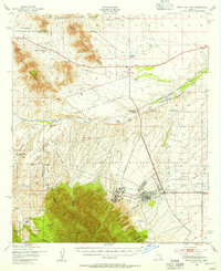
1948 Map of Fort Huachuca
USGS Topo · Published 1956About this map
Fort Huachuca serves as the central anchor for this mid-century survey of the high desert and mountain landscape where Pima, Santa Cruz, and Cochise counties meet. The presence of the Fort Huachuca Military Reservation dominates the southern landscape, featuring the Artillery Range, Target Range, and Apache Flats. Outside the military installation, the land is defined by extensive cattle ranching operations and the natural drainage of the Babocomari River and Mescal Creek.
Find a feature on this map
56 named features on this map. Tap any name to fly to it.
Don’t see what you’re looking for? This feature index may not catch every label — zoom into the map to look around manually.
Map Details
Editions of this 1948 Fort Huachuca Map
This is the sole edition of this map. No revisions or reprints were ever made.
Other maps of this area

1904 · Patagonia
USGS Topo · 1:125,000

1905 · Patagonia
USGS Topo · 1:125,000

1905 · Nogales
USGS Topo · 1:125,000

1914 · Hereford
USGS Topo · 1:125,000

1915 · Benson
USGS Topo · 1:125,000

1922 · Sunnyside
USGS Topo · 1:62,500

1922 · St. David
USGS Topo · 1:62,500

1926 · Whetstone
USGS Topo · 1:62,500

1932 · Stark
USGS Topo · 1:62,500

1932 · Fairbank
USGS Topo · 1:62,500