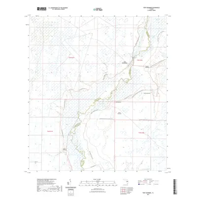
2021 Map of Fort Kissimmee
USGS Topo · Published 2021About this map
Fort Kissimmee sits along the winding course of the Kissimmee River, marking a landscape defined by seasonal water and dense hammock growth at the border of Highlands and Okeechobee counties. This interior Florida terrain is characterized by broad wetlands and sloughs, including Pine Island Slough and the ominously named Starvation Slough. The presence of the Fort Kissimmee Cem provides a specific point of interest for genealogists tracing the early settlers and military history of this river corridor. Extensive trail systems, such as the Florida National Scenic Trl and the Kissimmee Prairie Preserve State Park Trl, now navigate the mosaic of sawgrass and hardwood islands like McGuire Hammock and Mosquito Hammock. This modern survey reflects a region primarily dedicated to conservation and the preservation of Florida's prehistoric prairie environment.
Find a feature on this map
24 named features on this map. Tap any name to fly to it.
Don’t see what you’re looking for? This feature index may not catch every label — zoom into the map to look around manually.
Map Details
Editions of this 2021 Fort Kissimmee Map
This is the sole edition of this map. No revisions or reprints were ever made.
Other maps of this area

1952 · Fort Kissimmee
USGS Topo · 1:24,000

1952 · Fort Kissimmee NW
USGS Topo · 1:24,000

1952 · Lake Arbuckle NE
USGS Topo · 1:24,000

1952 · Lake Arbuckle SE
USGS Topo · 1:24,000

1952 · Lorida
USGS Topo · 1:24,000

1953 · Basinger
USGS Topo · 1:24,000

1953 · Fort Kissimmee NE
USGS Topo · 1:24,000

1953 · Basinger NW
USGS Topo · 1:24,000

1953 · Fort Kissimmee SE
USGS Topo · 1:24,000

1956 · Fort Pierce
USGS Topo · 1:250,000