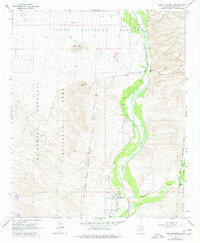
1964 Map of Fort McDowell
USGS Topo · Published 1977About this map
The Verde River corridor serves as the central artery for this mid-1960s landscape, illustrating the intricate relationship between water management and desert habitation. Within the Fort Mc Dowell Indian Reservation Boundary, the map documents several distinct eras of occupation, ranging from the Fort McDowell (Site) and a local Cem to active agricultural and residential outposts like Box Bar Ranch. To the west, the arid slopes of Mc Dowell Mountain and Lousley Hill provide a stark contrast to the verdant river bottom where the Jones Ditch and numerous siphons trace the movement of water across the valley floor. Purple revisions from the mid-1970s add contemporary layers to the survey, including a Golf Course and several miles of Jeep Trail, signaling the transition toward recreational land use in this corner of the Tonto National Forest.
Find a feature on this map
18 named features on this map. Tap any name to fly to it.
Don’t see what you’re looking for? This feature index may not catch every label — zoom into the map to look around manually.
Map Details
Editions of this 1964 Fort McDowell Map
4 editions found
Other maps of this area

1904 · Camelback
USGS Topo · 1:62,500

1904 · Ft. McDowell
USGS Topo · 1:62,500

1906 · Camelsback
USGS Topo · 1:62,500

1906 · Ft. McDowell
USGS Topo · 1:62,500

1930 · Cave Creek
USGS Topo · 1:125,000

1939 · Cave Creek
USGS Topo · 1:125,000

1954 · Mesa
USGS Topo · 1:250,000

1957 · Mesa
USGS Topo · 1:250,000

1958 · Mesa
USGS Topo · 1:250,000

1960 · Mesa
USGS Topo · 1:250,000