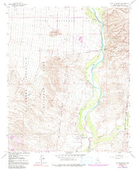
1964 Map of Fort McDowell
USGS Topo · Published 1991About this map
The Verde River corridor dominates this Maricopa County landscape, flowing south through the Fort McDowell Indian Reservation Boundary. The historical footprint of the area is anchored by the Fort McDowell (Site), adjacent to the active settlement of Fort McDowell and its nearby Cem. The map reveals a complex irrigation and ranching economy, evidenced by the Jones Ditch siphoning water along the river's western bank and family holdings such as Pemberton Ranch and Box Bar Ranch. To the west, the arid slopes of the McDowell Mountain Regional Park rise toward peaks like Lousley Hill, while the eastern terrain breaks into the deep cuts of Malpais Canyon within the Tonto National Forest. The presence of a Golf Course in the northern reach suggests the early stages of recreational development alongside traditional agricultural and tribal lands.
Find a feature on this map
16 named features on this map. Tap any name to fly to it.
Don’t see what you’re looking for? This feature index may not catch every label — zoom into the map to look around manually.
Map Details
Editions of this 1964 Fort McDowell Map
4 editions found
Other maps of this area

1904 · Camelback
USGS Topo · 1:62,500

1904 · Ft. McDowell
USGS Topo · 1:62,500

1906 · Camelsback
USGS Topo · 1:62,500

1906 · Ft. McDowell
USGS Topo · 1:62,500

1930 · Cave Creek
USGS Topo · 1:125,000

1939 · Cave Creek
USGS Topo · 1:125,000

1954 · Mesa
USGS Topo · 1:250,000

1957 · Mesa
USGS Topo · 1:250,000

1958 · Mesa
USGS Topo · 1:250,000

1960 · Mesa
USGS Topo · 1:250,000