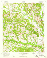
1955 Map of Fort Mitchell
USGS Topo · Published 1959About this map
Uchee Creek winds eastward toward the Chattahoochee River, defining the rural landscape of Russell County during the mid-1950s. This survey, compiled from 1945 and 1953 aerial photography, reveals a network of small communities and educational outposts such as Nuckols, Oswichee, and several local schools like Uchee Valley Sch and Sandbottom Sch. The eastern edge of the map is dominated by the Fort Benning Military Reservation, which straddles the Alabama-Georgia state line and includes landmarks like Lawson Field and Bradley Landing.
Find a feature on this map
33 named features on this map. Tap any name to fly to it.
Don’t see what you’re looking for? This feature index may not catch every label — zoom into the map to look around manually.
Map Details
Editions of this 1955 Fort Mitchell Map
3 editions found
Other maps of this area

1908 · Columbus
USGS Topo · 1:62,500

1914 · Seale
USGS Topo · 1:62,500

1929 · Columbus
USGS Topo · 1:48,000

1947 · Columbus
USGS Topo · 1:62,500

1949 · Fort Mitchell
USGS Topo · 1:24,000

1949 · Julia
USGS Topo · 1:24,000

1949 · Columbus
USGS Topo · 1:24,000

1950 · Fort Benning
USGS Topo · 1:24,000

1950 · Crawford
USGS Topo · 1:24,000

1950 · Seale
USGS Topo · 1:24,000