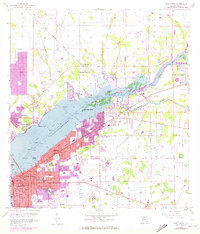
1958 Map of Fort Myers
USGS Topo · Published 1973About this map
The Caloosahatchee River serves as the central artery of this mid-century Florida landscape, dividing the urban core of Fort Myers from the growing settlements of Bayshore Manor and Salvista to the north. This document records a period of transition, where suburban expansion begins to bridge the gaps between historic citrus groves and wetlands. The urban grid is dense with community landmarks, including St Francis Xavier Sch, Lee Memorial Hospital, and the Fort Myers Cemetery.
Find a feature on this map
52 named features on this map. Tap any name to fly to it.
Don’t see what you’re looking for? This feature index may not catch every label — zoom into the map to look around manually.
Map Details
Editions of this 1958 Fort Myers Map
5 editions found

Other maps of this area

1956 · Telegraph Swamp
USGS Topo · 1:24,000

1956 · West Palm Beach
USGS Topo · 1:250,000

1957 · West Palm Beach
USGS Topo · 1:250,000

1957 · Tuckers Corner
USGS Topo · 1:24,000

1957 · Gilchrist
USGS Topo · 1:24,000

1958 · West Palm Beach
USGS Topo · 1:250,000

1958 · Fort Myers NW
USGS Topo · 1:24,000

1958 · Fort Myers SW
USGS Topo · 1:24,000

1958 · Olga
USGS Topo · 1:24,000

1958 · Alva SW
USGS Topo · 1:24,000
Featured Places
- Fort Myers, FL
- Fort Myers Shores, FL
- Orange Harbor Mobile Home Park, FL
- Sunburst RV Resort, FL
- Old Bridge Village, FL