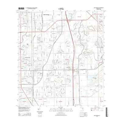
2015 Map of Fort Myers SE
USGS Topo · Published 2015About this map
Southwest Florida International Airport anchors the southeastern portion of this Lee County landscape, illustrating the modern aviation infrastructure that defines the region's 21st-century growth. The map captures a transitional geography where established residential developments like Pine Manor, Fort Myers Villas, and Page Park meet newer planned communities such as Renaissance and Gateway. Running north-south through the western half, the Tenmile Canal remains a prominent hydrological feature, paralleled by major transit corridors including S Tamiami Trl and Metro Pky. The presence of the Heritage Institute-Ft Myers and complex road networks like Daniels Pky reflect the suburban density of the Fort Myers periphery. This survey provides a clear look at how water management and transportation systems dictate the layout of these coastal Florida settlements.
Find a feature on this map
36 named features on this map. Tap any name to fly to it.
Don’t see what you’re looking for? This feature index may not catch every label — zoom into the map to look around manually.
Map Details
Editions of this 2015 Fort Myers SE Map
This is the sole edition of this map. No revisions or reprints were ever made.
Other maps of this area

1956 · West Palm Beach
USGS Topo · 1:250,000

1957 · West Palm Beach
USGS Topo · 1:250,000

1958 · West Palm Beach
USGS Topo · 1:250,000

1958 · Corkscrew NW
USGS Topo · 1:24,000

1958 · Fort Myers NW
USGS Topo · 1:24,000

1958 · Estero
USGS Topo · 1:24,000

1958 · Fort Myers SW
USGS Topo · 1:24,000

1958 · Olga
USGS Topo · 1:24,000

1958 · Alva SW
USGS Topo · 1:24,000

1958 · Fort Myers
USGS Topo · 1:24,000