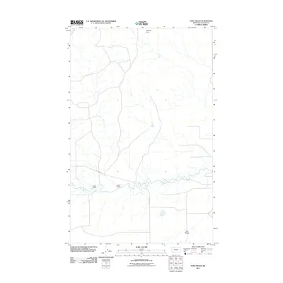
2011 Map of Fort Piegan
USGS Topo · Published 2011About this map
Fort Piegan serves as a primary marker on this landscape in Glacier County, where the plains meet the intricate drainage systems of the upper Missouri River basin. The meandering course of Cut Bank Creek dominates the southern half of the map, carving a path through the prairie. This watercourse is fed by several significant topographic depressions, including Cobell Coulee and Powell Coulee, which illustrate the natural erosional patterns characteristic of this region. To the north, the elevation rises toward Antelope Butte, a prominent landmark that provides a high vantage point over the surrounding territory. The local infrastructure is defined by rural corridors such as Brandvold Rd and Art Perrine Rd, which navigate the open country between the watercourses and the higher ground of the butte.
Find a feature on this map
7 named features on this map. Tap any name to fly to it.
Don’t see what you’re looking for? This feature index may not catch every label — zoom into the map to look around manually.
Map Details
Editions of this 2011 Fort Piegan Map
This is the sole edition of this map. No revisions or reprints were ever made.
Other maps of this area

1911 · Blackfoot
USGS Topo · 1:125,000

1960 · Cut Bank
USGS Topo · 1:250,000

1963 · Cut Bank
USGS Topo · 1:250,000

1964 · Cut Bank
USGS Topo · 1:250,000

1968 · Buffalo Lake
USGS Topo · 1:24,000

1968 · Rimrock Butte
USGS Topo · 1:24,000
1968 · Mission Lake East
USGS Topo · 1:24,000

1968 · Rocky Buttes
USGS Topo · 1:24,000
1968 · Kipp Lake
USGS Topo · 1:24,000
1968 · Mission Lake West
USGS Topo · 1:24,000