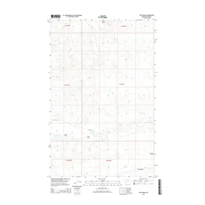
2014 Map of Fort Piegan
USGS Topo · Published 2014About this map
Fort Piegan serves as the focal point of this northern Montana landscape, situated near the winding course of Cut Bank Creek. The terrain is defined by a series of deep drainage features, including Cobell Coulee, Powell Coulee, and Wasteway Coulee, which cut through the high plains. These geographic depressions and the presence of Antelope Butte in the northern portion of the map illustrate the complex natural irrigation and runoff patterns of the region. Transportation across this rural expanse is anchored by Art-Perrine Rd, providing access between the coulees and the creek. The map also captures the confluence of Willow Cr and Cut Bank Creek, showing the hydrology that has historically shaped settlement and land use in Glacier County. This survey reflects the sparse, ranch-oriented development typical of the area during the early twenty-first century.
Find a feature on this map
15 named features on this map. Tap any name to fly to it.
Don’t see what you’re looking for? This feature index may not catch every label — zoom into the map to look around manually.
Map Details
Editions of this 2014 Fort Piegan Map
This is the sole edition of this map. No revisions or reprints were ever made.
Other maps of this area

1911 · Blackfoot
USGS Topo · 1:125,000

1960 · Cut Bank
USGS Topo · 1:250,000

1963 · Cut Bank
USGS Topo · 1:250,000

1964 · Cut Bank
USGS Topo · 1:250,000

1968 · Buffalo Lake
USGS Topo · 1:24,000

1968 · Rimrock Butte
USGS Topo · 1:24,000
1968 · Mission Lake East
USGS Topo · 1:24,000

1968 · Rocky Buttes
USGS Topo · 1:24,000
1968 · Kipp Lake
USGS Topo · 1:24,000
1968 · Mission Lake West
USGS Topo · 1:24,000