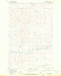
1968 Map of Fort Piegan
USGS Topo · Published 1972About this map
The Blackfeet Indian Reservation landscape is defined by the winding course of Cut Bank Creek and its complex network of seasonal coulees. This 1968 survey highlights the intersection of late-nineteenth-century historical landmarks with mid-twentieth-century industrial expansion. Fort Piegan and a nearby Ford reflect the early frontier activity along the waterways, while the Burlington Northern railroad and a prominent Pipeline crossing the northern section indicate the corridor's later role as a vital transportation and utility artery. Water management for the semi-arid high plains is evident in the Cobell Ditch and the Wasteway near the southern boundary. Terrain markers such as Antelope Butte and Gillam Coulee provide essential navigational points in a region characterized by deep-cut ravines and agricultural infrastructure, including a Corral and various Gravel Pits.
Find a feature on this map
17 named features on this map. Tap any name to fly to it.
Don’t see what you’re looking for? This feature index may not catch every label — zoom into the map to look around manually.
Map Details
Editions of this 1968 Fort Piegan Map
This is the sole edition of this map. No revisions or reprints were ever made.
Other maps of this area

1911 · Blackfoot
USGS Topo · 1:125,000

1960 · Cut Bank
USGS Topo · 1:250,000

1963 · Cut Bank
USGS Topo · 1:250,000

1964 · Cut Bank
USGS Topo · 1:250,000

1968 · Buffalo Lake
USGS Topo · 1:24,000

1968 · Rimrock Butte
USGS Topo · 1:24,000
1968 · Mission Lake East
USGS Topo · 1:24,000

1968 · Rocky Buttes
USGS Topo · 1:24,000
1968 · Kipp Lake
USGS Topo · 1:24,000
1968 · Mission Lake West
USGS Topo · 1:24,000